NuBot-RESCUER Team Description Paper 2009
Hui Zhang, Dan Hai, Ying Qu, Yong Li, Zhiqiang Zheng
College of Mechatronics and Automation, National University of Defense Technology, China
Abstract The paper mainly presents the approach of our rescue league robot team "NuBot-RESCUER" for RoboCup 2009. We introduce our locomotion system which is designed to be maneuverable on uneven terrains, discuss the composition of control hardware and control method. The method of map generation and the mapping process are also described. At last we introduce our new method to wireless sensor network aided rescue robot systems, we are looking forward to applying it in rescue robot tasks in future.
1 Introduction
RoboCup is an international research and education initiative. Its goal is to foster artificial intelligence and robotics research by providing a standard problem where a wide range of technologies can be examined and integrated [1]. The rescue league competition of RoboCup involves in search and rescue applications, provides objective evaluation of robotic implementations in representative environments [2].
NuBot-RESCUER is a team composed by students and originates from the former NuBot team which has taken part in RoboCupSoccer middle size league since 2003 [3]. We started working in the domain of rescue robot field from 2006. Up to now, we have designed two versions of the NuBot-RESCUER robots and participated in several robotic competitions in rescue, which led up to considerable results, and continuously won the championship of RoboCup China Open in 2007 and 2008. Our main focus concerns on design of Rescue Robot, SLAM based on Laser Range Finder, with an emphasis on advanced mobility, automatically mapping and wireless sensor network (WSN) aided rescue robot. We are going to present our recent approaches in RoboCup 2009.
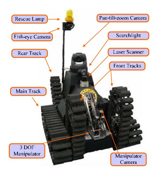
The robot (Fig.1)named $\beta$ was developed last year and was improved from its first version. Operator can control it from an efficient control interface. It is a 6-tracked vehicle, which is maneuverable on uneven terrains. When it cross a field explored, a map will be built automatically from its sensors' data.
The robot hardware bases around a 6-tracked vehicle, which can change configuration on uneven terrains. The architecture of chassis can be divided into three parts: front, middle and rear part. Each part contains two tracks. When facing stack
environment, the robot can overcome the stack by using its front and rear tracks up and down like 'climbing'. The 6-tracked construction is useful, especially crossing stairs, ramps and stepfield pallets.
2 Control Method and Human-Robot Interface
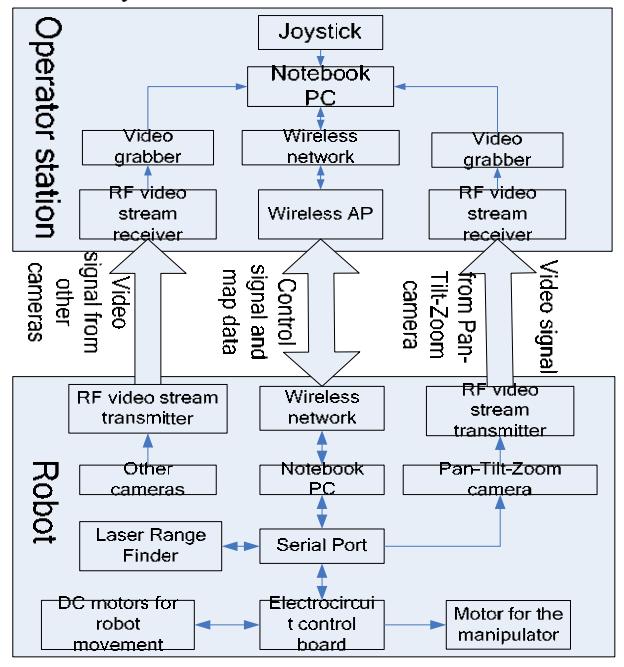
The hardware control system of robot β can be divided into 2 subsystems: robot and operator station . Fig2 depicts the main control block diagram of robot β.
The robot is equipped with a notebook PC (HASEE W220S ) as its onboard control PC. A pan-tilt-zoom camera (SONY EVI-D70P) is mounted on the robot as a main camera, two additional normal cameras are used for observing the environment and victims in several angles. A manipulator with 3DOF and a normal camera mounted on its top is installed, for getting close to victims and observing the situation clearly of them where the robot can't approach. Laser Range Finder (URG-04LX) is installed in front of robot for mapping the field explored. The chassis is the foundation of robot, its movement control hardware consists of DC motors, motor drivers and a microcontroller. The electrocircuit board is composed of DSP (TMS320F2812) and CPLD chip. These tracks are driven by motors (Maxon DC), in which there are encoders for the control of the speed and dead reckoning.
The β robot is a tele-operation robot. The communication between robot and operator station can be realized via wireless IEEE802.1a/b/g for control and map data transmission and RF for video stream transmission. Operator station consists of a notebook which is used to run the monitor software.
The operator use the main control of the robot based on notebook keyboard and a game joystick, with cameras and Laser Range Finder data to navigate to the disaster field. The user interface is progressed friendly and efficient. Operator can see real time video of the terrain in many angles and detect map which is automatically built from laser data the robot have collected.
We can package everything of the station for the robot operation in a suitcase and achieved quick set-up and break-down in the competition.
Our current proposal for the competition in 2007 China Open is to use the robot in essentially remote control mode. We are planning to incorporate the autonomous robot in yellow field this year.
3 Mapping Generation
Map building is a very important task for mobile robots. There are many methods for map building and the distinguished ones are the laser scan matching algorithm and the dead reckoning algorithm. Laser scans have several advantages such as reflect the information of the environment with high sampling rate, excessive angular resolution, dense and accurate range measurement, as well as perfect range and distance resolution. The laser scan matching algorithm is better used for map building than that of the dead reckoning algorithm for the reason of its high precision.
The normal methods for scan matching can be divided into two types: feature based matching and point to point matching. The high match speed is the advantage of feature based matching, but the precision of this method is very low. By contraries, the point to point matching has a better precision but a lower speed.
To achieve the goal of building a perfect map in real time, we combined both of the two methods above and generated a new matching method which is derived from clustering algorithm in the domain of pattern recognition. Firstly we extract feature points from the two laser scans and then use them to calculate the raw rotation and translation parameters between the two scans and transform the scans according to the parameters obtained. This implementation makes the two laser scans approximately overlapped and easily to implement the next precision matching. During the precision matching process, we use points matching algorithm to calculate the corresponding points in two laser scans for more precision parameters. Then combine the parameters now and before as the final result. The new algorithm have high matching precision as well as matching speed and fit for real time and precision map building.
From above, our matching algorithm is composed of two steps.
Step one, feature based matching. In this step Firstly we extract the corners and wall from scans as features. And then we find appropriate rotation and transform parameters in the result-space which is formed by transform parameters via matching every two feature points corresponding between the two scans one by one. We use every two feature points between the two laser scans to calculate the rotation and translation parameters one by one. All of the calculated results of the correct corresponding feature points are going to congregate around a point in the system of coordinate made up of the parameters and the right point stands for the appropriate parameters. Other calculated results of false corresponding feature points will scatter in the coordinate randomly and usually single ones which are difficult to form clusters composed of multitudinous point elements. So we find the group of the results, which have the biggest number of elements and the smallest error between every two elements. Then the center point of the group is the appropriate rotation and translation parameters.
Step two, point to point matching. In this step we use the ICP(iterative closet point) based algorithm to search precision rotation and translation parameters between the two laser scans. The least square function in the ICP algorithm has been improved for solving the problem of low speed convergence in the Apertrue-like problem in our new method.
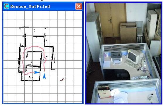
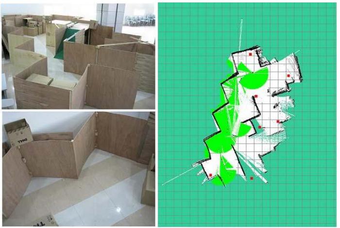
Fig 3 shows the result of our method in indoor environment. Fig 4 shows the result of our method in China open 2008.
4 WSN aided search and rescue
As the low-cost wireless sensor networks mushroom in application, rescuers have introduced WSN to track mobile robots. Now our laboratory is concerning on WSN aided rescue robot system, looking forward to applying it in rescue robot league.
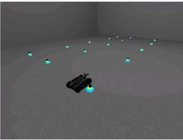
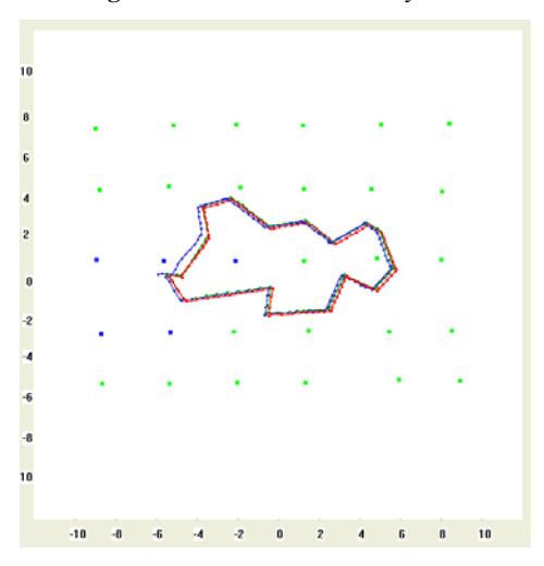
WSN is composed of a number of nodes with sensors you need. For nodes distributed dispersedly, WSN process the ability of computing dispersedly, sensing dispersedly and communicating extensively in the region distributed. In our early phase, we consider the positions of nodes are known initially. To tracking rescue robot, both the robot and the nodes must be equipped with wireless communication modules which are received signal strength indicator (RSSI). Using these modules we can measure the distances between nodes and robot, get the location of the robot with the locations of nodes. We have achieved fine simulate result in our simulation experiment based on USARSim as Fig(6).
Localization of robot involves in many items such as filtering of the noise and information fusion of multi-sensors. For example, signal strength attenuates are sensitive to the environment effect during its broadcasting. The measurements of RSSI have great noise lead to being deviated from real value. Without processing of the noise, the estimated location of robot will be deviated greatly from real location. Generally speaking, Bayesian Filter, especially Particle Filter is one of the most popular methods for noise processing. In our method, robot broadcasts its location first, then nodes that receive the broadcast can compute the distances between robot and nodes by received signal strength. At last we can fuse the measure information from these nodes by Bayesian Filter, eliminating effect of the noises among the state model and the observation model.
Besides benefit in tracking, there remain many other advantages of WSN. Firstly WSN facilitate the communication between operator and robots. If the point-to-point network between robot and operator doesn't work well, the video information and the victim information can transmit through the WSN, node by node. Secondly nodes can be equipped with the life detector. After one node detects a victim, the victim location can be transmitted to the robot through WSN. Simultaneously WSN can compute a optimal path for robot to approach victim. It will be much easier for robot to detect victim. Moreover nodes have great good effect on mapping. Node can sense the obstacle, dangerous region around it, and fusing sense information from all nodes, we can get a global map of the arena.
Now we are doing research in the simulation environment based on USARSim, and we will build a real environment for further research after having accumulated enough experience. The preparing work of building real environment has come into operation.
References
- http://www.robocup.org/
- http://www.isd.mel.nist.gov/projects/USAR/competitions.htm
- Hui Zhang, Dan Hai, Xiuchai Ji, Ying Qu, Yong Li, Zhiqiang Zheng. NuBot-RESCUER Team Description Paper 2008. RoboCup team description paper CD.