Design decisions of the SEU-RedSun Rescue 2009 Team on the Challenges of the Virtual Robot competition
Hui Shen, Cheng Qian, Xiao Li Xu
Southeast University, Automation Institute, Nan Jing 210096, China; Southeast University, Computer Science, Nan Jing 210096, China
Abstract This discussion paper highlights the design decisions of the SEU-RedSun Rescue Team on the challenges imposed by the 2009 competition. The SEU-RedSun Rescue Team focus on SLAM and applicability of several different robots. This paper shortly describes the main features and implementation of the SEU-RedSun rescue simulation team.
1 Introduction
Urban Search And Rescue is a challenging area of robotics. Generally the problem cannot be solved by single robot, and a team of heterogeneous robots that dynamically combines individual capabilities and cooperatively solves the task is needed. The Virtual Robot competition provides several elementary tests to demonstrate the progress of the skills necessary for urban search and rescue, including mapping, mobility, victim finding, communication and cooperation skills. This discussion paper highlights the design decisions of the SEU-RedSun Rescue Team regarding the challenges of the 2009 competition.
2 Our Goal
The aim of our team is to develop a system in which all of the rescue robots can make decision by themselves. The system was designed to have a hierarchical structure, with each component functioning independently. The robots including air robots all have the ability for mobility, exploring, victim finding, communication and cooperation. In addition, it is hoped that the system and underlying mathematics can be portable to the real robots with minor modifications.
Robots can make decisions on their own, however, in some special circumstances, they may also be controlled by human operators through the Wireless Communications Server. All control commands are sent via the base station. Our team is made up of four different robot types now: the P2DX, P2AT, Zerg and the AirRobot. However, in the competition 2008, only P2DX and P2AT had been used.The main reason was that the Laser sensor for Zerg named Hokuyu was only 4 meters which is too short, and sensors for AirRobot was not suitable for our arithmetic.
3 System Structure
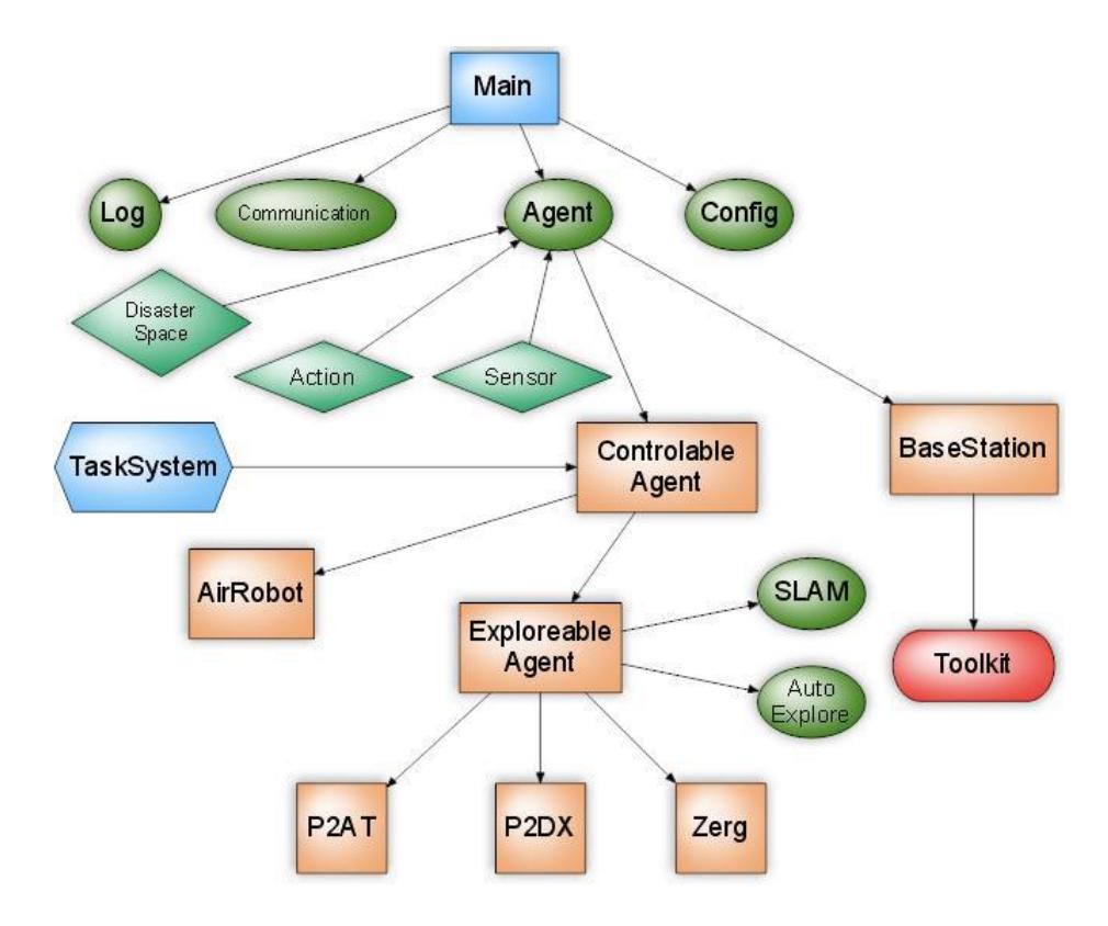
Figure 1 is our system structure.
The system we developed is easily to be extended. The whole system can be divided into several parts, the first part is Sensor and Action , in this part, the base connection and configure information mutual with UT server and Image-Server has been done. All the information received was defined from sensor, and all the information sent out was defined for action. The second part is Disaster Space which functions as robots memory. All the information such as map, position, direction, mission are stored in the Disaster Space. The third and the most important part is Agent. There are several agent types in the figure, like controllable agent, Exploreable agent, Base station, P2AT etc. Each type of agent has different ability. For instance, Controllable Agent has the ability to accept the control command from the Base Station. What's more, Exploreable Agent has the ability to explore the whole environment by itself. Zerg, P2DX, P2AT are all belong to both Controllable Agent and Exploreable Agent. So they have both control and explore abilities. Besides, there are task system which controls the movement of the robots, and SLAM , which mainly amends the position and direction of the robot.
4 Simultaneous Localization and Mapping
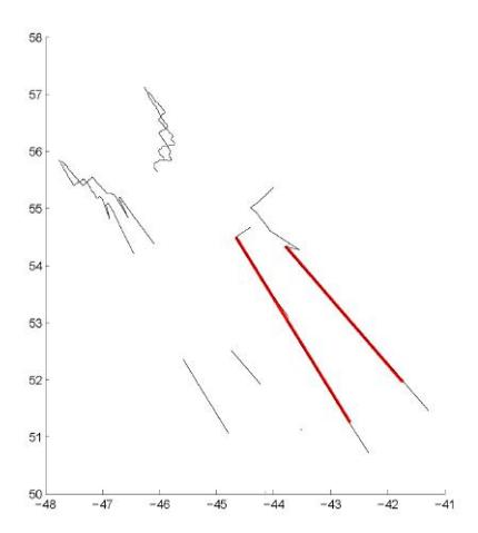
To achieve an accurately map, the robot should know its exact pose during the exploration, while the pose it reads from the odometry or inertial navigation sensors is of too large error. Laser range scanners can deliver highly accurate measurements. The scan matching algorithm we used in the 2008 RoboCup competition is the line matching, which is that straight lines of one scan are extracted every step, and lines of two consequent scans are matched. Figure 2 illustrates the line matching result. And a position estimate based on this line scan matching will be achieved that is impressive for indoor environments where most of the obstacles are of straight edges.
But when applying scan matching algorithm to outdoor environments, the result is not so accurate, sometimes the map distorts completely. Besides, the scan matching algorithm loses effectiveness even in indoor environment where the ground is rough.
To solve the problem with indoor rough ground, one of our current plans is to expand this algorithm to 3d scan matching. An additional constraint would be employed that the wall is vertical. This is real both in virtual robot and rescue robot league. It is still being studied by us that how to use this constraint.
Outdoor environments do not suit for such constraint, and new method should be proposed. We try to imitate human localization which seems only use cerebellum (like odometry sensor) and eyes (like cameras). We find it may be feasible to use a image processing method named panorama stitching. Panorama stitching is a process that stitch some small pieces of images to a large panorama using for example the SIFT feature of images.
This technique may be useful to localization in two different ways. One is stitching laser-scanned local map into the global map and estimate the pose by this process. The other is stitching pictures taken by camera and get the pose estimation. Each method may has its advantage and disadvantage and we plan to study them afterwards.
![Fig. 4. One Result of Panorama stitching from [5]](/tdps/rescue_simulation_virtual__2009__SEU/_page_3_Picture_3.jpeg)
5 Wireless Communication
Wireless Communication plays a very important role in transferring variety information among robots such as sharing the victim position and map information. We must create a structural level information management mechanism. Firstly, the base information is received from the connection layer, the connection layer parse the message for the first time and then send the package message to the message management. Secondly, The message management parse the message for the second time, and decide which message should be transmitted to the other robots, which message is unusable, which message should be updated to its own Disaster Space and how to update the Disaster Space. The soon message management worked, the robot could decide how to work in the environment using the information stored in the Disaster Space.
Message type we used are listed below:
- control messages by human operator which are sent from base station to control the robots straight.
- Disaster Space sharing information which is used to share the Disaster Space with other robots.
- Victim message
- Parameters of control center, the base station as the center will decide some parameters for all the robots.
- Cooperate message
In some situation, it is too far for a robot to send information directly to the base station. However, the information could be transferred by another robot. Link State Routing algorithm is used in our system. In the Disaster Space of each robot, a routing table is stored and updated every several cycles. Using the routing table, each robot knows how to send the information to the base station.
6 Path planing and Exploration
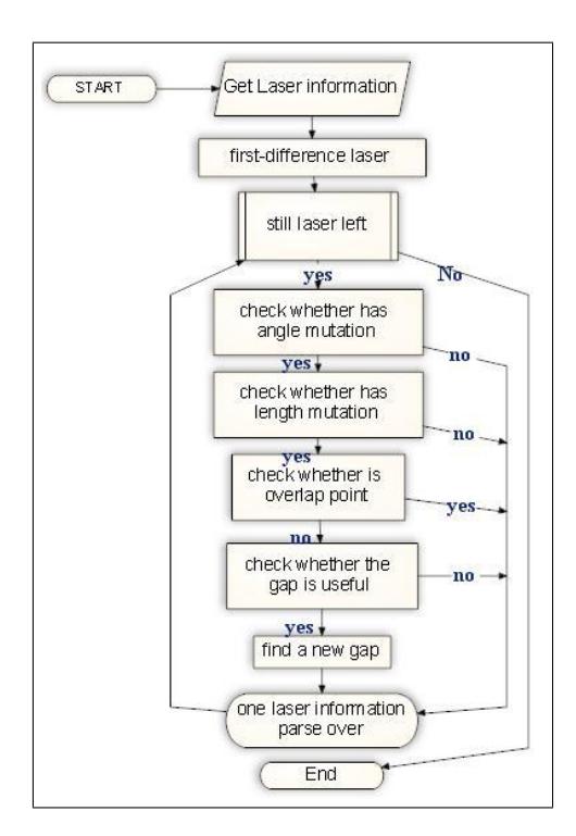
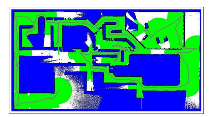
Exploration and Topological Map is the premise of path planing. The main point of automatic exploration is gap search. During the competition, the robots search for gaps and then cover the gaps. When there is no gap to be covered in the map, the search work is finished. The algorithm of gap search is showed in Figure 5
As the characteristic algorithm of gap search, A* and Artificial Potential Field(APF) was used. But both A* algorithm and Artificial Potential Field algorithm have obvious shortcoming. For example, time complexity of the A* algorithm grows exponentially with the map size. Though Artificial Potential Field algorithm is reacted, it often drops into the local minimum point. However, the combine of A* and APF can easily resolve those problems.
The whole process is in following steps:
- use gap search to establish the Topological Map.
- use A* to search the point to be covered in the grid map.
- use the the result of A* as the intermediate point to be the target of APF.
- use the APF to decide the way to move.
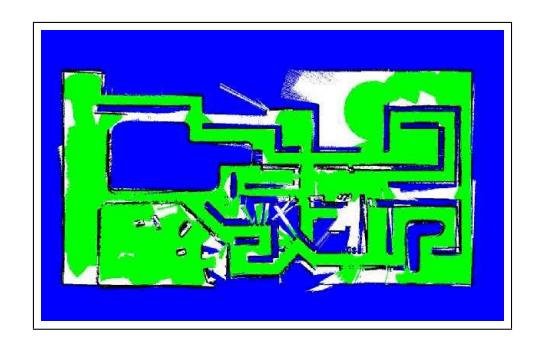
The algorithm is real-time and high efficient, and it overcomes the computational complexity of A* and the local minimum point problem of APF. The Figure 6 is the result of our system running in the map Factory.
7 Application in real Robot
Our school started the real robot rescue project in the end of 2008, and for software the system structure will as same as Virtual Robot, from which GUI control interface, SLAM and exploration algorithm will all be transplanted to the real robot. Because of the Virtual Robot, our real robot project is advancing rapidly.
8 Conclusion and Future works
In this paper, a few aspects of our current team as System Structure, SLAM algorithm, Wireless Communication, automatic exploration algorithm were introduced. The results we achieved give us more hope for the future. However, there are still much work to be done. The most important are SLAM algorithm and image processing.
References
- Wang, J., Balakirsky, S.: USARsim-manual3.1.1. (2007)
- Murphy, R., Casper, J., Micire, M., Hyams, J.: Mixed-initiative control of multiple heterogeneous robots for usar. Technical report, University of South Florida (2000)
- Balakirsky, S., Carpin, S., A.Kleiner, Lewis, M., Visser, A., Wang, J., Ziparo, V.: Towards heterogeneous robot teams for disaster mitigation: Results and performance metrics from robocup rescue. Journal of Field Robotics (2007)
- Lowe, D.G.: Distinctive image features from scale-invariant keypoints. International Journal of Computer Vision 60 (2004) 91–110
- Nazim Ashraf, I.N.J., Foroosh, H.: Near-optimal mosaic selection for rotating and zooming video cameras. ACCV 2007 (2007)