YILDIZ Team Description Paper for Rescue Simulation League Virtual Robots Competition 2017
Sırma Yavuz, M. Fatih Amasyalı, Erkan Uslu, Furkan Çakmak, Nihal Altuntaş, Salih Marangoz, M. Burak Dilaver, A. Erkam Kırlı
Yıldız Technical University, Computer Engineering Department, Istanbul, Turkey
http://www.robotics.yildiz.edu.tr
Abstract This paper is a short review of technologies developed by YILDIZ team for participating in RoboCup 2017 Rescue Simulation League Virtual Robot Competition. This year our focus is on improving our multi-robot SLAM abilities, and also adapting competition environment changes. Keywords: ROS, Gazebo, Multi-robot, Mapping, SLAM, Simulation, Multi-robot exploration, Air-robot, 3D exploration
Introduction
Probabilistic Robotics Group of Yıldız Technical University, which consists of a team of students and academicians, has been working on autonomous robots since its establishment in 2007. Our previous publications can be found at [1]. Our team took second place at Mexico RoboCup, Netherlands RoboCup and Brazilian RoboCup competitions. In Leipzig Robocup 2016, we finally took the first place. We have learned a lot of lessons over years as following:
- Our user interface can be improved.
- Our multi-robot SLAM algorithm is very useful.
- Our multi-robot exploration algorithm is very effective.
- We should be able to use air-robots.
- We should move to 3D-mapping.
The previous year, competition environment has changed from USARSim [4] to Gazebo/ ROS [5, 6], as discussed in The future of robot rescue simulation Workshop [8]. So our main effort was for adopting to the new environment. This year, we mainly focused on 3D related issues such as 3D mapping, 3D navigation, and 3D exploration. We also improved our interface.
YILDIZ TDP 2017
The team members and their contributions are listed below:
- Control interface: Salih Marangoz, Furkan Çakmak, Erkan Uslu
- Air-robot Navigation: Furkan Çakmak, Nihal Altuntaş, A. Erkam Kırlı
- 3D Mapping: Erkan Uslu, Furkan Çakmak
- 3D Exploration: Salih Marangoz, Nihal Altuntaş, M. Burak Dilaver
- Supervising, system design: Sırma Yavuz, M. Fatih Amasyalı
The team members and their contributions
| Role | Members |
|---|---|
| Control interface | Salih Marangoz, Furkan Çakmak, Erkan Uslu |
| Air-robot Navigation | Furkan Çakmak, Nihal Altuntaş, A. Erkam Kırlı |
| 3D Mapping | Erkan Uslu, Furkan Çakmak |
| 3D Exploration | Salih Marangoz, Nihal Altuntaş, M. Burak Dilaver |
| Supervising, system design | Sırma Yavuz, M. Fatih Amasyalı |
System Overview
The main software modules are user interface, localization, mapping, navigation and exploration. Robots on their own have all those modules equipped and ready-to-use. As a ground robot we use the Pioneer 3AT model. The sensors to be used are determined as Hokuyo UTM-30LX model laser scanner, RGBD camera and odometry sensors. For our 3D mapping experiments, we use an air robot (Rotors plugin with vi-sensor).
User Interface
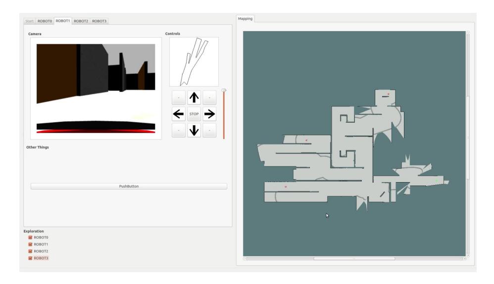
Our interface is designed using QT Creator and QT SDK [7]. This interface enables user to view built map, RGB video from each robot, laser depth data from each robot and also steer each robot.
Robots can be controlled by 3 different modes (manually, giving a target point and autonomous mode).
Multi-robot SLAM
RRSL tasks mainly focus on multi-robot cooperation. In rescue scenarios, simultaneous localization and mapping (SLAM) is the most desired ability. The previous year, we developed a multi-robot SLAM algorithm for Gazebo/ROS environment [12]. The details of the algorithm can be found at [3]. The implementation of the proposed multi-robot mapping algorithm is run on Gazebo (v.5), ROS (indigo), Ubuntu OS (v.14.04) environment. We currently work on migration of our code to the new competition environment (Gazebo v7, ROS Kinetic and Ubuntu LTS v.16.04). We also have plans to determine the robustness of our algorithm to added incremental sensor noise. For this mission, we plan to use our error generation framework working on Gazebo [9].
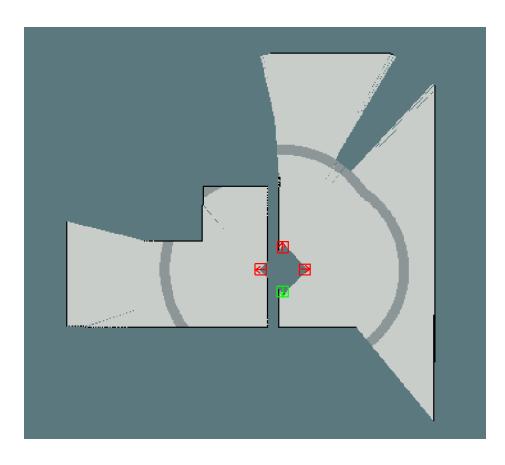
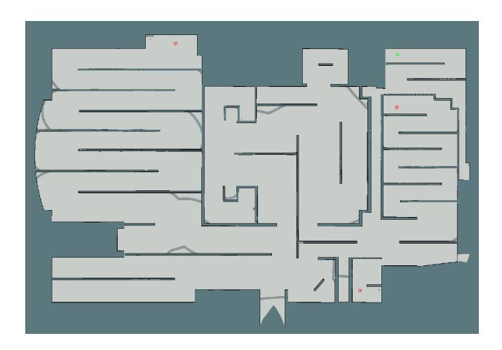
The initial map and final map of "Robocup 2016 VRL Final Run 2 Retry" can be seen in the figures below.
3D Experiments
3D modelling is very important task to be able to detect every details of the disaster area. This year, we have experienced with 3D mapping, navigation, and exploration. We use an air-robot Gazebo plug-in (Rotors [20]). We used a kind of stereo-vision based sensor (vi-sensor [21]).
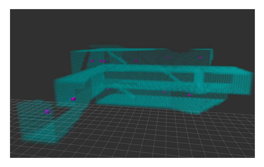
Octomap is a very common data structure to represent 3D environments [22]. We also used it in our experiments. Since we have no 3D-SLAM algorithm, we use vi-sensor without any noise. With this very optimistic approach, we could see our autonomous exploration capabilities.
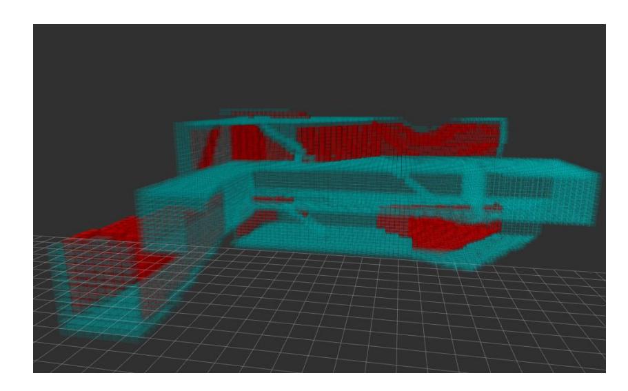
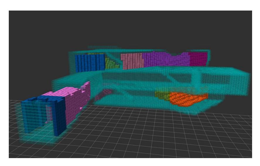
Our autonomous exploration strategy is based on finding the frontier cells [13], [16]. A frontier cell is defined as having unexplored neighbor grids in octomap. Frontier cells are shown in the figures below with red cells.
After defining the frontier cells, they are grouped by connected component algorithm [17]. The connected groups are shown with different colors.
The goals are defined as the mean grids of each group. It is possible that the mean grid can be an explored region. We currently work on the defining the target as the closest grid in the group to the center of the grid.
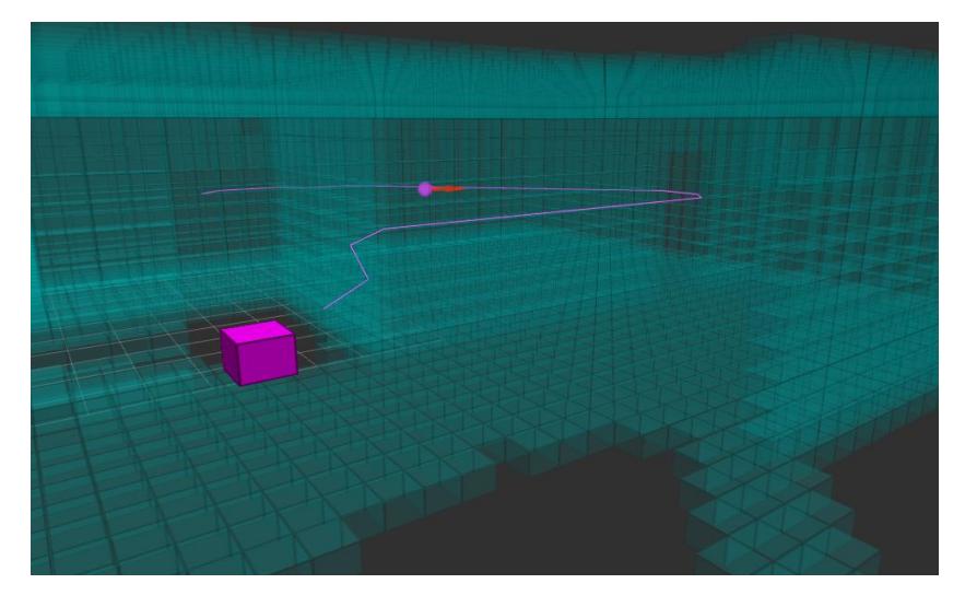
To select a goal, the distances to all the goals are calculated with 3D A* algorithm [19]. Then, the closest goal is selected. A path calculated with A* is shown with pink lines.
The robot moves to the selected goal. When it reaches its goal, frontier cells are again calculated for the current octomap. These process is continued until there is no frontier cell in the octomap. A sample video can be seen at https://youtu.be/geh4XyJqYfs.
Conclusion
In this paper, we give an overview of what our team developed for this year. This year we improved our control interface. A sample run can be seen at https://youtu.be/MMSUzG3lQ8g. We also concentrated to the usage of air robots and 3D mapping. Using a 3D-SLAM algorithm, multi-robot 3D mapping are in our future directions. We also developing automatic victim detection system which uses RGB data, thermal camera, voice, and movement detection.
Acknowledgments. This research has been supported by Turkish Scientific and Technical Research Council (TUBITAK), EEEAG-113E212 and Yıldız Technical University Scientific Research Projects Coordination Department (Project Numbers: 2015-04-01-GEP01 and 2015-04-01-KAP01).
References
- YildizTeam Publications http://www.robotics.yildiz.edu.tr/ tezlerveyayinlar/
- Thrun, S., Burgard, W., Fox, D.: Probabilistic Robotics (Intelligent Robotics and Autonomous Agents). The MIT Press (2005)
- Balclar, M., Uslu, E., akmak, F., Altunta, N., Marangoz, S., Amasyal, M. F., Yavuz, S.:An architecture for multi-robot hector mapping. In INnovations in Intelligent SysTems and Applications (INISTA), 2016 International Symposium on, pp. 1-5 (2016).
- Balaguer, B., Balakirsky, S., Carpin, S., Lewis, M., Scrapper, C.: USARSim: a Validated Simulator for Research in Robotics and Automation. In: IEEE/RSJ IROS 2008 Workshop on Robot Simulators: Available Software, Scientific Applications and Future Trends (2008)
- Koenig N., Howard A.: Design and Use Paradigms for Gazebo, an Open-source Multi-robot Simulator. In: Proceedings IEEE/RSJ International Conference on Intelligent Robots and Systems (IROS 2004), vol.3, pp. 2149-215 (2004).
- Quigley, M., Conley, K., Gerkey, B.P., Faust, J., Foote, T., Leibs, J., Wheeler, R., Ng, A.Y.: ROS: an Open-source Robot Operating System. In: ICRA Workshop on Open Source Software (2009)
- QT cross-platform software development, https://www.qt.io
- The Future of Robot Rescue Simulation Workshop, 29 Feb. 4 Mar. 2016, https: //staff.fnwi.uva.nl/a.visser/activities/FutureOfRescue/index.php
- YildizTeam Gazebo Skid Steering Plugin with Noise Model https://github.com/ YildizTeam/SkidSteeringNoiseModel
- Martins, J. A. S.: MRSLAM-Multi-Robot Simultaneous Localization and Mapping. University of Coimbra, M.Sc. Thesis, (2013)
- Lazaro, M. T., Paz, L. M., Pinies, P., Castellanos, J. A., Grisetti, G.: Multi-Robot SLAM Using Condensed Measurements. 2013 IEEE/RSJ International Conference on Intelligent Robots and Systems (IROS), pp 1069–1076, (2013)
- YildizTeam Multi-Robot-Mapping https://github.com/YildizTeam/ Multi-Robot-Mapping
- Visser, A., Bayu A. S.: Including Communication Success in the Estimation of Information Gain for Multi-robot Exploration, IEEE 6th International Symposium on Modeling and Optimization in Mobile, Ad Hoc, and Wireless Networks and Workshop, (2008)
- Quigley, M., Conley, K., Gerkey, B., Faust, J., Foote, T., Leibs, J., Wheeler, R., Ng, A. "ROS: an open-source Robot Operating System." ICRA workshop on open source software. Vol. 3. No. 3.2. (2009)
- Juli, Miguel, Arturo Gil, and Oscar Reinoso. "A comparison of path planning strategies for autonomous exploration and mapping of unknown environments." Autonomous Robots 33.4 (2012): 427-444.
- Yamauchi, Brian. "A frontier-based approach for autonomous exploration." Computational Intelligence in Robotics and Automation, CIRA'97., Proceedings., IEEE International Symposium on. IEEE, (1997)
- Vincent, Luc, and Pierre Soille. "Watersheds in digital spaces: an efficient algorithm based on immersion simulations." IEEE transactions on pattern analysis and machine intelligence 13.6 (1991): 583-598.
- Hart, Peter E., Nils J. Nilsson, and Bertram Raphael. "A formal basis for the heuristic determination of minimum cost paths." IEEE transactions on Systems Science and Cybernetics 4.2 (1968): 100-107.
- Roy Triesscheijn, Another faster version of A* (2D+3D) in C#, 2011, http://royt.nl/2011/09/24/another-faster-version-of-a-2d3d-in-c.html,
- Furrer, Fadri, et al. "RotorSA Modular Gazebo MAV Simulator Framework." Robot Operating System (ROS). Springer International Publishing, 2016. 595-625.
- Nikolic, J., Rehder, J., Burri, M., Gohl, P., Leutenegger, S., Furgale, P. T., and Siegwart, R., "A Synchronized Visual-Inertial Sensor System with FPGA Pre-Processing for Accurate Real-Time SLAM." IEEE International Conference on Robotics and Automation (ICRA), Hongkong, China, (2014)
- Hornung, Armin, et al. "OctoMap: An efficient probabilistic 3D mapping framework based on octrees." Autonomous Robots 34.3 (2013): 189-206.