Hinomiyagura Rescue Simulation Infrastructure Team - Crowd Simulation: Traffic Simulation Environment by network & area models
Kei Sato, Masaru Okaya, Shigeru Yotsukura, Tomoichi Takahashi
Meijo University, Aichi, Japan
[http://sakura.meijo-u.ac.jp/ttakaHP/Rescue index.html](http://sakura.meijo-u.ac.jp/ttakaHP/Rescue index.html)
Abstract Our interests are methods to analyze social phenomena that result from the behaviors of humans. Disaster and rescue domain is one of such social phenomena. RCRS provides a good simulation environment for the disaster & rescue domain. Tools and new simulators have been developed, and various application fields using RCRS have been presented. However, RCRS cannot simulate crowd situations such as evacuation from buildings, traffic jams caused by people, etc. We propose a traffic simulation environment that consists of a simulator of human behaviors in open space, and a GIS map format. The simulator can deal with crowd simulation in open spaces in town. The new format of GIS map is based on GML and defines properties of open space with the traditional network properties.
Introduction
RoboCup Rescue Simulation (RCRS) is a comprehensive simulation system that integrates the results of various disaster simulation and agent actions [6]. It was designed to simulate the Hanshin-Awaji earthquake and also other disasters by plugging or replacing components. The architecture of RCRS allows users to customize the simulation environments by inputting the appropriate GIS data, plugging in disaster simulators with their regional peculiarities, and implementing their prevention plans as agent codes. Agents autonomously behave according to the situation. Their actions involve evacuation from buildings, going to safe places, asking for help, extinguishing fires, rescuing victims, etc. Multi agentbased simulation (MABS) provides a platform to simulate human behaviors in such social issues.
Casti showed that MABS traffic planners, TRANSIMS, simulated traffic patterns in Albuquerque, New Mexico, and was used to assess the impact of new road construction [1]. Given assumptions that drivers obey red and green lights, but otherwise are free to decide for themselves how to drive, ABS has applied to alleviate traffic congestion at intersections [3]. Implementations of traffic simulation are important to MABS. Because the agents send their will where they want to go to the traffic simulator, the traffic simulation systems collect the wills, resolve conflicts among the wills if any, and calculate the next location of the agents.
In RCRS, two traffic simulation systems have been presented. The first one was designed to simulate similar behavior as TRANSIMS [4]. The traffic simulation used properties related urban traffic control such as signal controls, turn pockets, etc. With these properties, a micro level simulation was done; however, it caused the simulation of RCRS unstable at the earliest version of RCRS. The second one is a presently used simulator. It was designed to simulate traffics at any situations in more stable manners than the first one. In 2009 infrastructure competition, Hinomiyagura proposes a new traffic environment that will simulate following situations,
- evacuation from buildings, underground malls,
- behaviors of crowds in parks,
- traffic simulation of cars and pedestrians.
The traffic environment is composed of followings.
Traffic simulator: The simulator simulates the behaviors of humans, cars, or other moving objects by network model or free space model depending on the properties of roads.
GML based map format: GIS files in RoboCup are binary files with specified properties. The properties are roal related ones such as the length, width of roads, whether it has side walks or not and others. Besides roads, open areas are important at disasters. The open areas are used as refuges, or roads.
Rescue Scenarios and problems
Figure 1 shows one of rescue scenarios that the present RCRS cannot simulate. Followings are the rescue scenarios.
- When disasters occur, people in buildings evacuate to outside. Then they go to parks, for example, that are assigned to refuges.
- Inside the buildings, people take shelter in a doorway and move to the aboveground floor by stairs.
- Around entrances of buildings, there are many people. They are persons evacuated from the buildings, and injured persons carried by stretchers.
- Rescue teams arrive and start to save rescue operations. Some teams carry the injured to hospitals, others extinguish fires and the others enter the buildings to save ones trapped inside the building.
The left of Figure 1 shows an image of the evacuation of people and the movement of rescue teams from their stations. The behaviors of people are simulated as movements in a free space and the results are presented with 3D models. It takes a lot of computation resources, a huge amount of data to model the environment, commutation power to calculate and to present them, etc.
The right of Figure 1 shows an image of simulations by our traffic simulation environments. Movements of agents on some parts of roads, such as around the entrance of big buildings or at parks, are simulated by free space model. The movements on the other parts are simulated by the network model that is used in the RCRS.
The traffic simulation based on the combination of the free space model and the network model makes (1) the required computation resources and powers less than the one in the left figure, and (2) it possible to simulate the behaviors of human in detail.
![A image of assumed rescue scenarios ([left]: evacuation of people is simulated by free space model. [right]: the evacuation on roads is simulated by network model.](/tdps/rescue_simulation_infrastructure__2009__Hinomiyagura/_page_1_Picture_10.jpeg)
System architecture
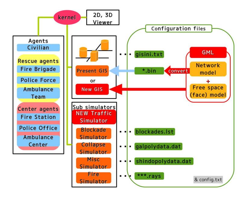
Figure 2 shows system architecture that our traffic environment is used. Following two issues need to be modified to use our traffic environment.
GIS: The property area is added to geographical properties of GIS map files. GML based file formats are specified and a new GIS simulation has released. As a byproduct, a converter from the text file of GML based format to the bin files of the present RCRS is also provided.
traffic simulator: Our traffic simulator simulates the behavior of agents whether they are on roads or open spaces with the area property.
The rescue agents are the same as ones of the present RCRS. They use the same move commands and others as the RCRS.
Crowd simulation in RCRS
Evacuation planning under dynamically changing disaster situations is important. Inside the buildings, people take shelter in a doorway. Outside the buildings, ambulances and fire engines rush to the sites and people move to safe places. There are two approaches for simulating crowd situations. One approach is a model based approach. Models such as a physical model are used to calculate the behaviors [2]. The other approach is agent based simulation (ABS). The ABS proceeds the simulation as a result of actions of agents [5].
The ABS approach has advantage that it can simulate rescue operations. The present RCRS has the following two commands that handle rescue operations in buildings.
AK RESCUE: An ambulance team rescues a buried human. AK LOAD: An ambulance team loads an injured humanoid.
These RCRS command does not reflect the situations inside buildings or interactions among other agents. For the first problem, we proposed an idea to combine RCRS and USARSim as one disaster and rescue system [7].
We design a new traffic simulator for the second problem, because it is assumed that the collisions among people are important in simulation of evacuating behavior from building. RCRS(ver.0) was designed to simulate situation of three days after the occurrence of earthquakes. And one simulation step was set to be one minute. A pedestrian who walks at 4 km/h proceeds about 65m during a minute. This time step is too long for crowd simulations. The time step is divided to short one enough to simulate the collision among people in the crowd. Figure3 shows a screenshot of our new traffic simulator. On the roads or buildings that have properties of area, it simulates microscopic movements of agents.
![Evacuation behavior simulation at disasters. [left] A snapshot of original RCRS. [middle] A new GIS viewer that deal roads with *area* property. [right] A snapshot of simulations that agents out of an exit of building cut across the area in front of the building.](/tdps/rescue_simulation_infrastructure__2009__Hinomiyagura/_page_4_Picture_1.jpeg)
Area definition and RCRS map format
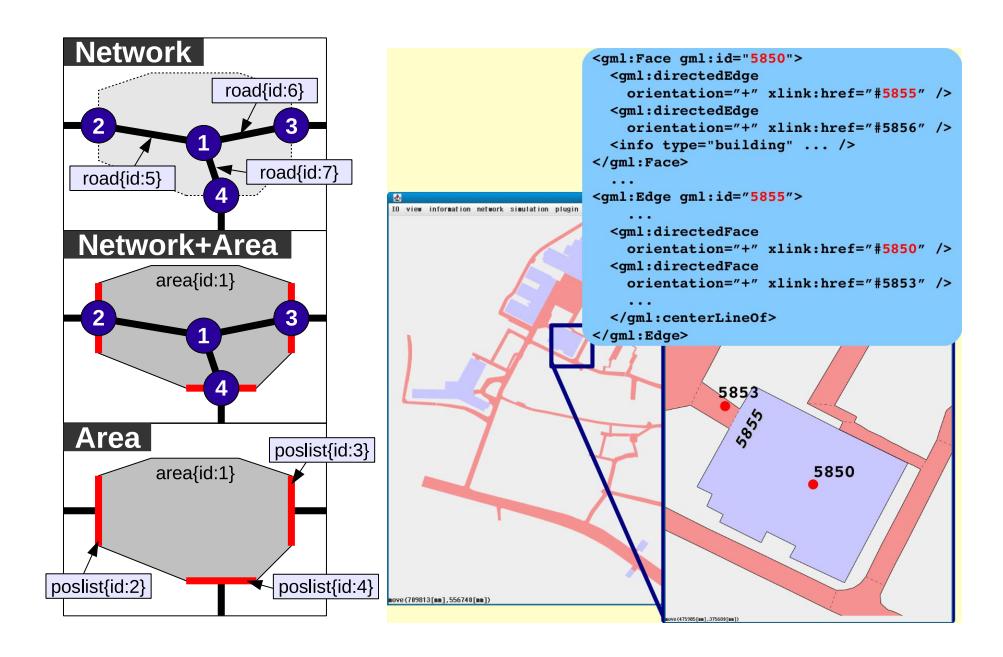
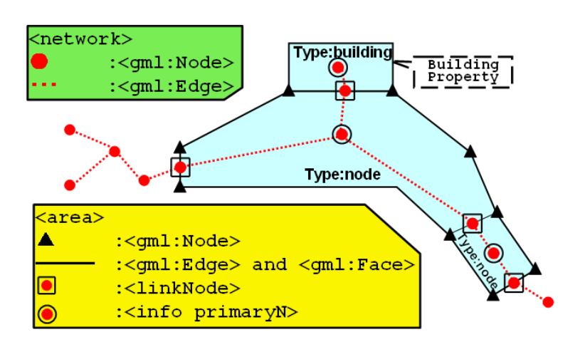
Area is a new property of GIS to simulate crowds in RCRS. We propose a map format based on GML(XML). The left of Figure 4 shows the corresponding between the network model and models with area property. The area property is defined by the surrounding node points. The left shows a snapshot of map viewer corresponding for the new format. Table1, 2 and Figure 6 in appendix shows the tags and geographical definitions.
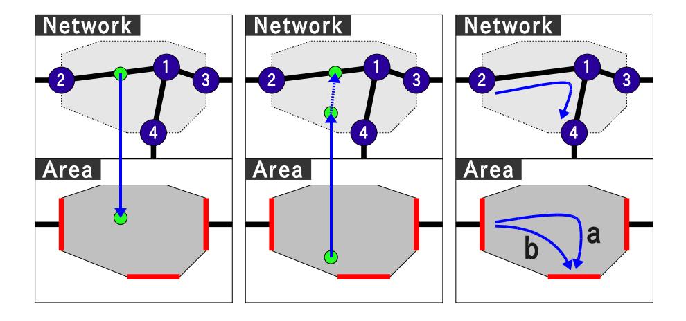
Figure 5 shows the difference in traffic simulations between the network model and our area model.
- The location of an agent between nodes corresponds to inner points of the area.
- The motions in the area is simulated by free space models. An agent that goes from node 2 to 4 is simulated as it goes by the shortest route b, instead of a. In future, several models of human behaviors at open space can be implemented using this model. [2]
Tags of network properties
| network property | gml:Node | gml:id | ID:unique |
|---|---|---|---|
| gml:directedEdge | xlink:href | ||
| orientation "+"/ "-" | |||
| gml:pointproperty | gml:Point | ||
| RCRS:Nodeproperty | |||
| gml:Edge | gml:id | ID:unique | |
| gml:directedNode | xlink:href | ||
| orientation "+"/ "-" | |||
| gml:centerLineOf | |||
| RCRS:Roadproperty | |||
Tags of area property
| Area property | gml:Node | gml:id | ID:unique |
|---|---|---|---|
| gml:directedEdge | xlink:href | ||
| orientation "+"/ "-" | |||
| gml:pointproperty | gml:Point | ||
| gml:Edge | gml:id | ID:unique | |
| gml:directedNode | xlink:href | ||
| orientation "+"/ "-" | |||
| gml:directedFace | xlink:href | ||
| orientation "+"/ "-" | |||
| gml:centerLineOf | |||
| linkNode | xlink:href | ||
| gml:Face | gml:id | ID:unique | |
| gml:directedEdge | xlink:href | ||
| orientation "+"/ "-" | |||
| info | type | ||
| primaryN | |||
| RCRS:BuildingProperty* | |||
Summary and Discussions
This paper presents a traffic simulation environment that deals with crowd behaviors in open spaces in towns. It expands the application fields of RCRS and makes disaster & rescue simulations practical ones. GML based map file format makes easy to transform other map files to RCRS map files. This leads RCRS are used to simulate at towns all over the world.
References
- John L. Casti. Would-Be Worlds: How Simulation is Changing the Frontiers of Science. John Wiley and Sons, 1997.
- I. Farkas D. Helbing and T. Vicsek. Simulating dynamical features of escape panic. NATURE, 407:487–490, Sep. 2000.
- Kurt Dresner and Peter Stone. Multiagent traffic management: A reservation-based intersection control mechanism. In The Third International Joint Conference on Autonomous Agents and Multiagent Systems, pages 530–537, July 2004.
- T. Kaneda, F. Matsuno, et al. Simulator complex for robocup rescue simulation project - as test-bed for multi-agent organizational behavior in emergency case of large-scale disaster. RoboCup-2000: Robot Soccer World Cup IV, 2001.
- G. Lammel, M. Rieser, and K. Nagel. Bottlenecks and congestion in evacuation scenarios: A microscopic evacuation simulation for large-scale disasters. In 5th Workshop on AGENTS IN TRAFFIC AND TRANSPORTATION (AAMAS2008), May 2008.
- RoboCupRescue. http://www.robocuprescue.org/.
- S. Yotsukura, K. Sato, and T. Takahashi. A framework of simulation system for rescue control/training center. In SICE Annual Conference 2008, Aug 2008.