Eslam Team Description Paper
Morteza Faghani, Kasra Shirazi, Alireza Aghayari, Artin Aziziyan
Eslam High School Iran
Abstract This team description paper illustrates the main characteristics of the Eslam rescue robot team for Robocup competition. We have experience of participating in junior co-space league for 3 years and we were in Japan RoboCup, now we decide to continue our activity in Simulation league. Because this is the first year that this team is participating in the RoboCup Rescue simulation virtual robot competition, we have decided to collect other team's experiences from the last IranOpen competition and we have followed the last international match result in Canada to gather useful strategies from other teams. Virtual Simulation uses ROS and Gazebo to enable advanced multi-agent robotic simulation allowing simulation of rescue situations. It allows the inclusion of multiple types of robots including land and air-based robots with a wide range of sensors and actuators. At first step, we have concentrated to explore in the map via a laser sensor.
1. Introduction
Virtual Robocup is a competition and research to develop a professional method of robotics for navigation and rescue during natural disasters like earthquake and tsunami. This idea is created from a terrible earthquake in Japan. In this way, the Virtual RoboCup decided to hold a challenge to motivate students of the world for designing virtual robots to solve this issue and build real autonomous robots.
The virtual robot competition uses Gazebo and ROS to allow the simulation of varying disaster environments. Within this, land and air- based robot agents can be simulated. A variety of different sensors can be used within this and the placement and integration of these can be varied. This is our first year of competition in RoboCup Rescue Simulation; we are grateful to the work published by other teams which has been extremely useful in understanding the challenge and also the material developed by the 'Future of Rescue Simulation' workshop.
During the IranOpen 2018 RoboCup Competition, Virtual robot workshop attracted our attention, we found this field exciting for our team members. Because we are familiar with ROS Framework and our team leader had experience of Championship in Rescue Simulation league for 2 years in RoboCup, we decide to participate in the virtual robots league if our TDP accepted for participation. Strategies of Eslam will have mounted on ROS and Gazebo Framework. In this article we demonstrate ideas about controlling obstacle, finding human and mapping. We hope these efforts of Eslam school student's help humanity during natural disasters.
2. Source code structure
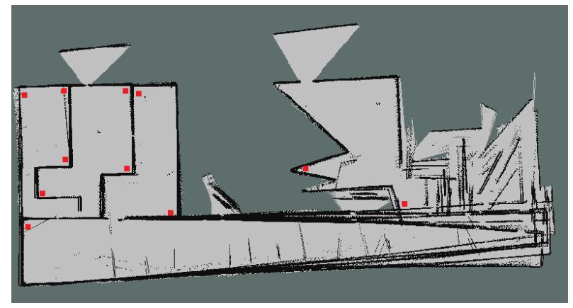
Robots situation is not known at beginning and there is lots of unknown area in the map that should be explored by robots, thus exploration and creating the map is vital, in this way we utilize RVIZ software to show the map that is generated by robot. In this section, we concentrate on 2 important parts such as SLAM and Victim Detection.
2.1. SLAM
Simultaneous localization and mapping are the most important segment in the virtual robot challenge. SLAM's duty is to explore the world, create new a map and find robot position in the map. This task will continue until a victim detected, then the robot should decide what to do in the next step. For this objective, we utilize some prepare package (like G-mapping, AMCL and Hector) of the ROS framework. These packages and their performances are mentioned below.
G-Mapping: This package is located in ROS wrapper for SLAM's gmapping. This method creates a 2D map from data of Rao-Blackweellized particle filter from laser range scanner and sonar sensors.
AMCL: For localization purpose, this package uses Monte Carlo localization approach [8]. In our investigation, we find this method and package more efficient than others.
Hector: Hector procedure creates a map and that is a SLAM approach without odometry data. Some advantage of this package is:
- 1- High update rate of modern LIDAR systems
- 2- Provide 2D pose estimates at the scan rate of the sensors (40Hz).
3- Successful results on Unmanned Ground robots, Unmanned Surface Vehicles.
G-Mapping method and package were easier for us to use in comparison to AMCL and Hector, thus we prefer to utilize the G-Mapping method for this Competition.
2.2. Victim Detection
This year is our first experience in virtual robot league, thus we study all of TDP's to find the best and easiest method for victim detection. In this way, we found the Echoic [10] team method is better than other teams.
In this Simulation league, detecting victim's autonomously is critical for all teams to collect more scores. Finding man and woman by a robot with a monocular camera is not solved by most of the teams. RGB-D cameras like Kinect make the detection task easier. Our mission system consists of three processes:
- Noise reduction.
- Image segmentation and ROI detection to reduce the search space and improve the whole system performance both in terms of time and accuracy [10].
- Applying detection and recognition algorithms on the detected ROI to validate object type for each region [10]
This process is completely illustrated in references, thus we did not demonstrate in again and because we do not access to great hardware like RoboCup system, we decide to use Yolo method, because it has less computational process compared to other methods.
We developed this method accurately and analyzed for live video-based image processing. According to figure 2, Yolov3 runs significantly faster than other detection methods with comparable performance.
Yolo's method applies a single neural network to the full image. This network divides the image into regions and predicts bounding boxes and probabilities for each region. These bounding boxes are weighted by the predicted probabilities. Our model has several advantages over classifier-based systems. It looks at the whole image at test time so its predictions are informed by the global context in the image.
This table is developed by firebolts team for Asia open Competition to identifying live human.
HOG package is useful for victim detection by a Histogram of oriented gradients and human shape. This package is consists of face detection, shape detection, motion detection, and heat detection.
Now we are working on both methods to increase our score and accuracy of victim detection.
![Figure 1: Output of Yolov3 method [11]](/tdps/rescue_simulation_virtual__2019__Eslam/_page_3_Picture_0.jpeg)
![Figure 2: Yolov3 is faster than others [11]](/tdps/rescue_simulation_virtual__2019__Eslam/_page_3_Figure_2.jpeg)
Table 1: Fire bolt team strategy
| Feature | Component | Approach |
|---|---|---|
| Shape feature | Edge, Shape | (PCA),(HOG),(DHG) |
| Motion feature | Optical flows | ,(HOS),(LBP),(HOF) (LTP),(LUV) |
| Appearance feature | Color, Texture | ,(NRCPB),(CSLBP) ,(LTP),(HAAR),(LID) (LBP),(HOG),(CHO) |
| Combination feature | - | ,(HOG)+(LBP) ,(HOG)+(LUV) ,(HOG)+(HOF) ,(HOG)+(CHOG) |
3. Exploration
Automatic exploration in environments is important and fundamental for several real-world applications, including map building, search, and rescue. In most situations if we want the robot to move to various points of the map or if we had to sync the robots we will need to transmit the data from the laser, camera and the position of the robot.
3.1. Autonomous exploration
The first and easiest way to transmit data is to save the data in a folder of documents, in a way that the robot's data get saved in a folder and be available in the needed situations to make a decision from the choices possible. One of the disadvantages of this method in comparison to other methods is that it takes to much time.
Two main and important methods:
- 1: Publisher Subscriber
- 2: Service Client
Publisher – Subscriber
In some decisions, we will have to refresh the data and have our hands on new data on any given moment. For this operation, we will need to publish the data. The robot will upload its position and other important data on a port and an IP and the other part of the code will receive the uploaded data as a subscriber.
Service – Client
The method mentioned will not be useful in some situations such as checking victims because we won't see the victims at any moment of the game so we will use the Service – Client method. This means a request will be sent from one part to another. The answer will be saved by the second part and will be sent back to the first part.
3.2. Multi-Agent exploration
MRL team description in 2013 RoboCup competition defines the method for multi-agent exploration and this algorithm seems great and useful for us, thus we decide to utilize it. We design a frontier based method [5] for multiagent exploration. When a robot performs a frontier detecting process, it uses the range scan data and detects each sequence of laser beams that return a distance more than a specific value, as a frontier and put frontiers location between the sequence's start and end [3]. MRL method is a treebased that manages robot movement in the map. In this method, each frontier will be represented by a node and each path between frontiers with an edge. The blue circle in Fig 3 is the initial location of the robots when spawning near BS. This is root of the tree. We assume a level for each node. The level of the root is always zero. Each frontier can be detected from a visited frontier that is its child. The level of a child is 1 unit more than its parent's level [3].
For example, in Figure 4. , , have same one level, , have the same level with two number and frontier can be detected from but in this case, the parent level is less known as the main parent. It means that the level of is 2 [3].
The global cost map will not show an accurate direction in the map and it will show places that weren't scanned by the laser. Local cost map will show us a map that is very accurate and it's based on the radius that is scanned by a laser. The local cost map will update the data at the time that we will need new data. By using a global cost map and local cost map we could find the best path. One of the key algorithms for finding the path is merging. Merging will give us a different perspective from different robots in different points of the map. By using the Merge algorithm and the ROS software we will be given an accurate and complete version of the map. These will help us to find the best path from all the various options. Now we are working to merge the map of different robots.
![Figure 3: Exploration graph [3]](/tdps/rescue_simulation_virtual__2019__Eslam/_page_5_Figure_2.jpeg)
4. Conclusion
In this team description paper, the main states of Robots are illustrated for the RoboCup challenge, but these states are not sufficient and it is essential to work on more states and strategies for participating in RoboCup 2019 competition. Now we are working on some strategies like victim detection, mapping and we are increasing our knowledge on the ROS framework.
The main topic of this article is created from our experiences in the rescue simulation league, co-space league, and other team description papers. I hope this effort of Eslam teams helps humanity during earthquake disasters.
References
[1] Amigoni, F. Shimizu, M. Taleghani, S : RoboCup Rescue Simulation League Virtual Robot Competition 2016. [2]Golshahi, Y et. al: S.O.S. Team Description Paper Proceeding of Robocup 2013. [3] Taleghani,S. Shayesteh,M : MRL Team Description Paper for Virtual Robots Competition 2013. [4] Mavaei,S. Varasteh, M: MRubiX Team Description Paper for Virtual Robots IranOpen2016; [5] Yamauchi, B. : Frontier-based exploration using multiple robots: In Proceedings of the International Conference on Autonomous Agents (AGENTS), pages 47 - 53, New York, NY, USA, 1998. ACM. [6] Yata, T. Kleeman, L. : Wall following using angle information measured by a single ultrasonic transducer: In Proceedings of the IEEE, International conference on Robotics & Automation, 1998. [7] Krzysztof, R. : A Portrait of a Genius: Formal Aspects of Computing (2002) 14: 92–98 . [8] Fox, D. Burgardy, W. : Monte Carlo Localization: Efficient Position Estimation for Mobile Robots. [9] Zaman, S., Slany, W., Steinbauer, G.: Ros-based mapping, localization and autonomous navigation using a pioneer 3-dx robot and their relevant issues. In: Electronics, Communications and Photonics Conference (SIECPC), 2011 Saudi International. pp. 1–5. IEEE (2011) [10] Mohammad Javadi, Nika Sadat Mousavi Zarandi and etc, Echoic Rescue Team Description Paper RoboCup 2018 Virtual Robot League. [11] Joseph Redmon, Ali Farhadi, "YOLOv3: An Incremental Improvement", University of Washington.